Parish Footpaths
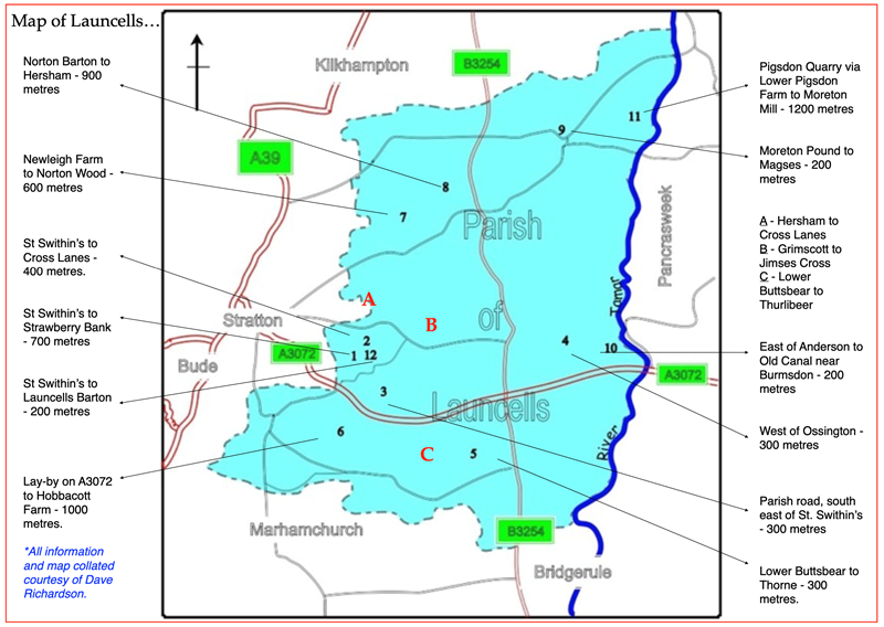
Please find a list of paths in the parish below:
Path No. |
Route |
App. Length Km (miles) |
1 |
St Swithin's to Road South East of Diddies |
0.72 (0.45) |
2 |
North of St Swithin's to South of Cross Lanes |
0.44 (0.27) |
3 |
Road South of Launcells to Road A3072 |
0.64 (0.40) |
4 |
Road East of Ossington to Road West of Anderton |
0.28 (0.17) |
5 |
Land at Thorne Farm to Buttsbear |
0.28 (0.17) |
6 |
Hobbacott Farm to Road North of Hobbacott Down |
0.96 (0.60) |
7 |
New Leigh to Norton Wood South West of Norton Barton |
0.60 (0.37) |
8 |
Norton Barton to Hersham |
0.92 (0.57) |
9 |
Morton Pound Farm to Magses |
0.20 (0.12) |
10 |
Land at Anderton to Old Canal |
0.20 (0.12) |
11 |
Moreton Mill to Road East of Lower Pigsdon |
1.20 (0.75) |
12 |
St Swithin's to Road North of Underwood |
0.20 (0.12) |
|
|
Total distance: |
6.64 (4.13) |
In the Parish of Launcells there are 12 Public Footpaths, totalling just over 4 miles (6.6 km).
One path leads into Bude-Stratton, the other paths are entirely within the parish. There
are no Bridleways in Launcells.
Sadly, only 7 of our footpaths provide meaningful walks, another one is a
dead-end, and the other 4 do not have any public access to them.
Cornwall Council have classified all footpaths (based on estimated usage and strategic location) as
Gold, Silver or Bronze. Of the 7 accessible paths, 5 are Gold, and one each Silver and
Bronze. Our longest path is three quarters of a mile (1.2 Km) and the shortest is just
over 200 yards (0.2 Km) long.
Infomation provided by
Dave Richardson